We’re taking a look at our planet’s oceans, and seeing how and where the important work into studying our seas takes place, as well as finding out how the data collected by marine expeditions translates to research that informs our climate and conservation efforts.
In this episode
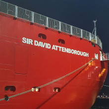
00:49 - A tour of the RRS Sir David Attenborough
A tour of the RRS Sir David Attenborough
Will Whatley, BAS & Maria Fox, BAS & Kelly Hogan, BAS & Elaine Fitzcharles, BAS
Our planet’s oceans are under significant stress. 40% of the fish caught at sea is ‘bycatch’ and is killed without even being eaten. Carbon dioxide entering the water from the air is making the seas more acidic and dissolving the shells of crustaceans; and millions of tonnes of microplastics are affecting food chains and altering the development of some creatures: a paper just out shows that some sea urchin larvae aren’t growing properly for this reason.
But, to solve a problem, you first have to understand why it’s happening. And a key component is data. Unsurprisingly, when it comes to the oceans, that means getting your feet wet! A lot of marine study is done aboard research vessels, and one such vessel is the Royal Research Ship “Sir David Attenborough”.
The ship, operated by the British Antarctic Survey, was launched in July of 2018, hosts the infamous autonomous underwater vehicle ‘Boaty McBoatface’, and cost £200 million to build. That sort of money means the research vessel packs a serious scientific punch. I got the chance to visit just before the ship set sail a few weeks ago bound for Antarctica…
Will - I do remember as a young budding zoologist making a promise to my parents that one day I would meet David Attenborough. But as I turn the corner at the docks here in Harwich, I do have to say I do remember him looking a bit different on the telly. But regardless, it does sound like we are going to be treated to a tour of the ship, including the labs and the data center. But before that, we have a couple of very special interviews on the bridge. So let's go and have a look.
Captain Whatley - My name is Will Whatley and I'm the captain of the Royal Research Ship Sir David Attenborough.
Will - It's very exciting to be on board. I don't think, even though I saw the tagline of it being a £200 million build, I don't think I truly appreciated just how big this ship is until I first saw it. So for the benefit of the audio listeners at home, what kind of a size of ship are we looking at here?
Captain Whatley - The ship is immense in its size and its complexity. It's 128.9 meters long, 24 meters wide. The distance from the waterline to the top of the ship is 45.3 meters. It's 15,000 tons, but the actual technology density within the ship is the thing that's really big. It's so, so dense. There's so much capability packed into one hull and it's really unique in that regard. The ship does have really good ice breaking capability. The ship is designed to actually ride up on top of the ice and break it with the weight. And the design specification for the ship is to be able to do three knots in one meter thick ice. We can break stuff a bit more than that at slower speeds. And last season we completed our ice trials in the Antarctic very successfully and the ship was really maneuverable and performed very well.
Will - You're off on your second voyage now to the Antarctic. How long is it gonna take you to get down there?
Captain Whatley -
We leave on Sunday and it'll take about three weeks to get down to the Falklands and then another four or five days to get to the Antarctic from there. And there's good excitement amongst the crew. We're all very much looking forward to it. Even having been quite a few times now, it never gets old. Going to the Antarctic is something that we always want to do.
Will -
I'd assume you're therefore well stocked if you're at sea for three weeks.
Captain Whatley - We certainly are, yes. We actually do our main stock up here, so all the dried, the frozen, and all the stuff that lasts and we have a good stock up on fresh food as well before we go and we've got all the cargo and the food and the fuel for all the Antarctic research stations as well. So, we're not quite ready. We've still got a few days left, but we're nearly there.
Will - Our ship of this size presumably has quite an impressively sized crew.
Captain Whatley - We've got around 35 marine crew at the moment and we could take about 55 scientists so we could be up to 90 people in total, which is a fair amount.
Will - How long can you stay at sea? Is there a particular length that you usually go between stocking up on land?
Captain Whatley - Well, it very much depends on what we're doing and and what the mission is, but the main figure is around 60 days, which is actually quite a long time. Within that time you can achieve some, some pretty big science projects.
Will - What are the conditions like in the Southern Ocean? I've heard they're quite turbulent. I assume that there's counter measures in place for the science going on here.
Captain Whatley - There are. The ship's really well designed with those conditions in mind. So all the thrusters are really powerful so we can actually stay on station in rough weather and keep delivering marine science even in those rough conditions in the Southern Ocean.
Maria - I'm Professor Maria Fox from the British Antarctic Survey and I'm leading a team inside the AI lab at BAS focused on automating route planning for this beautiful vessel that we are now sitting on.
Will - Now I've never had the privilege of going to the Antarctic or the Antarctic ocean, but I can't imagine as much in the way of traffic or roads. So when you're using an AI to map out the best available course, what are you measuring? What are you taking into account?
Maria - So you are exactly right. There's no road network, there are no traffic rules, but there are extremely complex dynamic hazardous environmental conditions. So in particular in Antarctica you have very high winds, you have surface sea ice that's quite extensive for most of the year. You have icebergs that move around. Strong currents, very big waves, all the worst things you can imagine for actually being in a boat.
Will - How much time or distance is this hoping to shave off more traditional routes?
Maria - So it depends quite a bit, but what we know is that shipping accounts for the largest carbon emissions in polar science. So the goal here is to do what we can to reduce the carbon emissions of shipping in that context. And anything we can do is going to be beneficial. So what we're aiming for is something similar to what you see in a an in-car navigation system like Google Maps. But you know how, when you put your destination in, Google Maps will tell you the fastest route and it will also now tell you an eco route and it will promise to reduce your fuel consumption by some percentage. So we are aiming for a similar thing where the captain sets the goal of where they're trying to go and we will generate alternative routes, fast ones, low fuel use, low carbon emissions, et cetera. And usually that involves trying to avoid traveling through the thick ice because that is extremely fuel expensive.
Will - And these measurements that you're taking, presumably a lot of parameters, are they coming from measurements taken on the boat or are they taken from satellites? Is it a mix of the two?
Maria - It's a mix of the two at the moment. The bulk of our data comes from satellites. So we have several different forms of data, but it can be seen as measurements of quantities like current or wind or sea ice at particular geophysical locations in the ocean. So we get that data from satellites primarily, but historical data sets even forecast data sets, weather forecasts, sea ice, forecasts and so on. So yes, lots of different kinds of data, but it has to be given to us in a way that we, we can relate to locations in the ocean
Will - And as you said, marine vessels account for a great amount of the emissions that we produce. So this is an AI being attached to a flagship boat, very expensive, high-end, you know, a wonder of science type thing. But presumably in the future there is scope to attach this to all kinds of marine vessels so that everyone can have their go at shaving what emissions they can off their marine journeys.
Maria - Yep, that's a great question. So our code is all open source now. We made it open source just a few weeks ago. So anybody who wants to try doing some automated route planning in the ocean can use our code and also hopefully collaborate with us or raise issues and discussion with us because that's the goal of open source co-development.
Kelly - I'm Dr. Kelly Hogan. I'm a marine geophysicist and I work at the British Antarctic Survey. Most of my job involves coming on research ships like the Sir David Attenborough to collect data in the field around places like Antarctica and Greenland and then I take it home and analyze it and try to understand what's happening. What we're looking at here actually is some echo sounders and those are instruments that are on the bottom of the ship that send down sound to the seafloor and then we listen back for the echo and we do various things of that information. So the one over here on the left hand side is something called a multibeam sound. It basically maps out the depths to the seafloor and we get a nice 3D image of the sea floor. And these marks that you are looking at here which are sort of big stripes or gouges on the seafloor are where icebergs have plowed through the muds and the sands that are down there. Another kind of echo sound that we have here looks just straight down from the ship and straight back up again. And we get the layers of sediment that are there on the seafloor and just beneath. And we use that to, if we want to take a sample from the sea floor, we use that to see where there might be good layers to go and target.
Will - And what are we hoping to find when we sample these samples?
Kelly - Well a lot of my research focuses around understanding where ice used to be and how it may have retreated or decayed away in the past. The reason that we want to do all this now is because as our climate is warming, we are looking at trying to understand how an ice sheet might respond to either a warmer atmosphere or warmer air or warmer waters getting close to the ice and melting them. So what we can do if we take a sample of the sediments for example, we can tell things like did the ice decay away by melting into actual meltwater that went into the oceans or by chopping off lots of icebergs and dropping big pebbles and sands. So we can actually tell that from the sediments that we recover from the sea floor.
Will - And once we have all this useful information, how are we hoping to communicate it to the policy makers or the general public?
Kelly - Yeah, that's a fantastic question. I mean, we always work really hard to pass on the information that we find to both policy makers and the public. That can be through stories from the media or social media for the general public through our website, um, through tweets, through videos. There's lots of outreach that we do with schools and education. It's really important to pass this on to the younger generation now coming through, they have the energy for this. They are the ones inheriting our planet. It is difficult to get the right information to policy makers, but we do the very best we can in terms of getting the key results to them. In KBIs of policy documents like the intergovernmental panel for climate change, the IPCC reports a lot of our key results for Antarctica and Greenland will go into those documents and that's what policymakers use to help their planning and help them make their decisions.
Elaine - My name is Dr. Elaine Fitzcharles, I'm the senior laboratory manager for the British Antarctic Survey.
Will - So you've brought me down here to the labs. Now this is eerily reminiscent of A-Level chemistry labs here. It looks, I'm sure you won't mind me saying, a bit bare at the moment, save for a few fumigation hoods. Presumably there's something a bit more important going on here than me setting fire to my lab coat.
Elaine - This is the main laboratory that we're in. It is very much a large open space, but the intention is that when we have science cruises on board, the scientists can bring their own specialist equipment on board to use when they're here. So it is very much just space for them to fill and it will fill when we have a science crew.
Will - It's massive <laugh>, it's really big and it goes on.
Elaine - So we have 13 laboratories on this ship and we also have four additional container laboratories that are very specialist in their function that we can bring on board when the science needs it. So it's a massive amount of space to be able to do science in.
Will - And a huge selection of freezer rooms as well.
Elaine - We do have quite a lot of freezers on board. We have a walk-in freezer, a walk-in fridge. We've got minus 80 freezer storage and we've got lab fridges and freezers scattered throughout. But because we collect things that are in the cold, we have to preserve them in the cold to bring them back.
Will - And what sort of exciting things are going to be going on in here?
Elaine - So there will be water analysis. What we do is look at the nutrient content of water. We've got other labs where we've got specialist equipment to look at how salty the water is. So it's all about what's there for the algae, the plant life in the ocean, the animal life in the ocean to feed on. And how that then affects bigger things of fish, mammals, everything. It's all linked. So we're looking at the baseline studies. We'll also have people who are collecting marine invertebrates. So krill is one that we study quite a lot. It's a very fundamental food source in the southern ocean. And they'll be coming in here to look at things like lipid content. They'll look at diet of different animals. So it's very much a multi-functional space. We'll have people looking at sediment cores to look at what the seabed is like. So yes, it's about being able to adapt it to the different cruise requirements.
Will - And how are you going to go about getting your samples?
Elaine - So one of the things with the ship is we have several places we can drop things over the side. So we can put equipment over to collect water, we can put corers down to the seabed to collect sediment samples off the seabed. We've got nets that we can use to fish, we can take some fish off the seabed as well. So we can put them off the back of the ship. We can put them off the side of the ship. And in really bad weather we've got what is called the 'moon pool', which is essentially a large hole through the middle of the ship that we can put the equipment through. If it's not safe to put it over the side or if we're sitting in ice, we can still do the science and study what's on the seabed underneath the ice.
Will - When someone explained to me what the moon pool was, they said 'it's a giant hole in the middle of the boat'. And I thought surely that sounds a bit counterintuitive. I'm going to assume that you have it all sorted out.
Elaine - Yes, we do. So currently it is closed. We have a cover over the top so we make sure that it's safe and we would only open it when we're actually needing to use it for science. But it's very much just a hole through the middle of the boat. It doesn't affect the boat's safety. We've done a lot of modeling and how it affects the boat's performance when it's at sea as well. So it's perfectly safe, but it is a hole through the ship. <laugh>,
Will - I've had to huddle back into my car because the weather here is doing its best Antarctic impression. But hopefully that gives you some idea of some of the many wonderful things going on during this ship's expedition to the South Pole and to the RRS David Attenborough, Bon Voyage.
16:00 - What do we do with oceanographic data?
What do we do with oceanographic data?
Emma Boland, BAS
Emma Boland, from the British Antarctic Survey, specialises in modelling the Antarctic ocean, to see how the changes in salinity and carbon dioxide are affecting how water around the south poles moves. She takes much of her data from research vessels, such as the ‘David Attenborough’, and spoke about how this collected data is behind the forefront of research and science policy.
Emma - I mostly use computer models in my work. So I look at representations of the ocean, in something that's a bit like a version of Minecraft, but mostly just the ocean in it. And what we do is we do experiments on the ocean that we can't do in real life, but the models are only as good as our observations because the only way to get a good model is to compare it with the observations to check if it's doing a good job or not. So we really, really need things like the ‘Sir David Attenborough’ to go out and take these important measurements for us so we can check our models. And the ‘Sir David Attenborough’ is particularly important because it's going to spend half the year in the Southern ocean that surrounds Antarctica. The Southern Ocean is what we call a data desert. We really don't have very many good observations of the ocean there. That's partly because it's so inhospitable. It's got very strong winds, strong waves, and half the year there's lots of sea ice surrounding it. And also because it's just very far away and hard to get to. So every single measurement that the ‘Sir David Attenborough’ takes is going to be really valuable.
Will - And what sort of data would you be hoping that it takes in order to help your research?
Emma - Well, really importantly, we just need more measurements of basic things like temperature and salinity as we go down into the ocean. So satellites can look at the surface of the ocean, but they can't tell us what's going on inside. We really need to go out there and take physical measurements. So one of the things that the ‘Sir David Attenborough’ will be doing is dropping pieces of equipment off the side that will go further down deep, deep, deep kilometers deep to take temperature and salinity measurements from down deep. The other thing that's great about the Sir David Attenborough is it's really going to act as a kind of mothership for lots of extra measuring equipment. So we'll send out things like Boaty McBoatface, which is what we call an autosub. It's a little yellow submarine that's controlled from the ship. We can send that out to take measurements under the sea ice where we can't get traditional equipment.
Will - Boaty McBoatface was tragically absent from my visit, which is a real great shame. But it's good to hear it's still doing good work. What is the data being sent back helping to inform you about current movements in the South Pole and how that spreads out into the rest of the ocean?
Emma - To understand what the measurements tell us, we first have to understand why the Southern ocean is so important. So it might feel very far away. It is very far away from us here in Cambridge, but the Southern ocean plays a really, really important role in the climate system. In fact, it plays a bit of an outsized role. It's about a third of the ocean, but it takes up about three quarters of the heat and half of the carbon dioxide that the ocean takes up for us. So it really plays a kind of outsized role. We sometimes call it the lungs of the ocean. So a lot of heat and carbon dioxide from the atmosphere enter into the ocean there and they get locked away for hundreds or even thousands of years. So it is doing us a kind of great service in that if that heat and carbon dioxide wasn't taken up by the ocean it would stay in the atmosphere and make the global warming that we experience that much worse. So it's doing this really important role of taking up heat and carbon dioxide, but we don't have very many measurements of that going on, so we don't really understand exactly what controls those numbers. So what determines how much heat and carbon dioxide go into the southern ocean? Well, we don't really know. So we need more measurements to try and work out the processes that are going on down there.
Will - With a changing climate now that we have. Do you expect these movements and these tides and these currents to change in any significant way?
Emma - We do expect changes. So especially in the Arctic we've got sea ice melting very rapidly. In the Antarctic, it's more of a mixed picture. We've got some areas that are losing a lot of sea ice, are there areas where sea ice is growing and that changes the amount of really cold, salty water around Antarctica and that water then enters into the rest of the ocean and affects the whole of the circulation of the oceans. So we're already finding through the measurements that people take for the British Antarctic survey on previous research cruises, that these kind of currents are changing. The amount of cold dense water that's being made around Antarctica is reducing and we don't really know if that's gonna continue into the future. And that's where the models come in. If we can model these processes and find similar things going on in the models, then we can play the model forward and see what might happen in the future.
Will - All of this research is all well and good, but if it can't inspire a policy change or a change in the public's outlook, then perhaps it isn't truly serving its purpose. So how can expeditions and research like this help to inform governmental policy and public perception?
Emma - Well, that's very important to mention because the British Antarctic Survey are representatives of the UK government, so we have a really important role to play. First of all, the science, as I discussed, is really important to help us understand how the climate is changing, and going to change. If we don't understand how the climate is going to change, we can't make effective policies to deal with that change. And the other thing is that our work really highlights the importance of this amazing ecosystem out there. So all the animals and wildlife that you see, even though the wildlife that you can see, there's very important ecosystems happening in the ocean with krill and all sorts of things. So the British Antarctic surveys work in Antarctica. What we hope is that we can bring the importance of those, um, environments home and inform the government and inform the public of how important they are, how important it's to protect them. I don't know if you remember on Frozen Planet a few years ago, some of our researchers revealed for the first time the extent of plastic pollution that was making its way all the way to those really pristine environments in Antarctica. And that had a massive follow on impact on changing the way that the UK looks at plastic waste. So it's really important to keep raising awareness of the kind of importance of these environments and how they're changing.
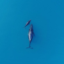
22:40 - Whales act as carbon sinks
Whales act as carbon sinks
Heidi Pearson, University of Alaska Fairbanks
The extent of oceanographic data is not just for measures of physical changes to our planet’s hydrologic systems, it also plays a key part in ecology and conservation. Indeed a study out just this week showed that whales, which not only play a pivotal role in keeping ecosystems healthy, might also be so massive that they act as carbon sinks as well. Heidi Pearson, of the University of Alaska Fairbanks,spoke about how oceanographic data is vital to continued studies on ocean health, and how much of a role whales might play in carbon storage.
Heidi - There are many ways that understanding the basic oceanography helps in conservation. And one big part of biological oceanography is this thing called the biological carbon pump, which describes how carbon gets from the surface layers of the ocean down to ocean depths. And with some of the research that my team has been doing, we're looking at how whales might play a role in the biological carbon pump.
Will - What kind of oceanographic data needed to be collected in order for this study to work?
Heidi - We need information on whale population sizes and whale mortality rates, body size, and then we need information on oceanic food webs, and photosynthetic rates, and nutrient levels in the water. The depth of what we call the thermocline, the temperature gradient in the water. So this type of work really pulls together many aspects of ocean science all tied to whales.
Will - And so what are some of the ways that whales can act as carbon sinks?
Heidi - Well, there's two main pathways that my team describes in our paper, and we separate them into what are called direct pathways and indirect pathways. So these direct pathways are what I just mentioned. So whales are very big. They live for a long time. And just like you and me, they're made of carbon. And so this means that they can store a lot of carbon for a long period of time. They can take it out of the atmosphere just by living their daily lives. And then when they die, these very big carcasses, most of them will sink to the sea floor. And we believe that most of them will sink to the deep sea. And sinking to the deep sea is really important in terms of carbon sinks because once something that is made of carbon like whales sink to the deep seafloor, that carbon will be trapped from the atmosphere for thousands of years, maybe even longer. And so that's really the exciting part about understanding this carbon sink. So these direct pathways that I've just described, we have a pretty good handle on it scientifically. We're fairly confident in the numbers we're getting, but in the scheme of things, it's a pretty small contribution if you think of the overall global carbon budget. So the other pathway is this indirect pathway, and this is where whales essentially release byproducts. So poop, urine, slough skin, placentas in the case of breeding females. And these byproducts are rich in nutrients. And this is important because the upper parts of the ocean are oftentimes devoid of nutrients. And nutrients are important because that's what phytoplankton take up. And phytoplankton, you can think of like tiny marine plants, they are sucking up CO2 from the atmosphere. And so when we have more nutrients in the surface, waters deposited by whales, we have the potential to stimulate phytoplankton growth and thus more capture of carbon from the atmosphere. So that indirect pathway is a lot more intricate than those direct pathways. We have less scientific understanding of that, but we believe that there is more potential for carbon capture through that indirect pathway than the direct pathway.
Will - And if the ways that these whales can be carbon sinks are so far reaching, both primary and secondary, it sounds like a very difficult task of quantifying how much effect they have in terms of being a carbon sink. And indeed is there a risk potentially of overselling their level of carbon capture?
Heidi - Yes, there is. And that was one of the driving factors for this paper. So as I mentioned, we have pretty high scientific confidence in some of these pathways fairly low at the moment in these other pathways. And the risk is overselling the carbon benefit of whales. We just don't have the data we need to fully put a carbon value on all of the ways that whales might be helping to capture, store and sequester carbon. And the risk is putting a value on whales, the carbon carbon values. And then once we get the scientific data, we find out that it doesn't quite support it. And there have been some pretty high dollar economic figures put on the carbon values of whales that our team was concerned about. And so we were attempting to rein in the science on this and our paper. We do put forth an economic framework that can be populated once we do get the requisite data in hand. But right now we don't feel like we are at a place scientifically to put an economic figure on the carbon value of whales.
Will - But you would still be confident in saying that even if their level of carbon capture is not significant enough to warrant this kind of investment, it's still an extra reason as to why they should be conserved?
Heidi - It is, absolutely. So we know that whales make some contribution to carbon dioxide removal. What we don't know right now is the full scale. And another thing we're trying to do with this work is put what we call a confident lower bound on the ability of whales to remove carbon dioxide, saying, okay, they at least do this much. We think they have this potential, but we need more data to get there. We also advocate for the precautionary principles. So there's really no downside to conserving whales. It's a low regret, low risk strategy for conserving ecosystems as a whole. So we know that whales can help to keep ecosystems healthy. We know that they can help to combat the biodiversity crisis, which we are also in. And we also know they have these climate benefits. And so if we conserve whales, we know that there's a lot of ecosystem benefits that will occur.
Will - So it strongly advocates more oceanographic data to be collected.
Heidi - Yes, absolutely. And we have a great team. We've outlined some of the outstanding questions. We've outlined some research pathways, so I think we know how to get there. We just need a little bit more time and resources to answer all of these critical questions.
Related Content
- Previous NASA's Dr Z
- Next Nuclear fusion, and magnetic air pollution








Comments
Add a comment